Dogwood Acres Campground is easy to reach from both Interstate 81 and Interstate 76 (the Pennsylvania Turnpike), as well as the cities of Pittsburgh and Harrisburg. The campground is ideally located in South Central Pennsylvania, only 35 miles from Harrisburg and Gettysburg, and only 11 miles from the Carlisle Auto Shows. You may use the interactive Google Map, below, to obtain detailed travel directions from any point of origin or to obtain travel directions from Dogwood Acres to any attraction or destination.
There is always something fun happening at Dogwood Acres Campground. In addition to everything that is happening right here at the campground, there is a wide range of events that are scheduled throughout the season in Cumberland County and the surrounding communities. The campground is ideally located in South Central Pennsylvania, only 35 miles from Harrisburg and Gettysburg, and only 11 miles from the Carlisle Auto Shows. The following are some of our suggested area attractions.
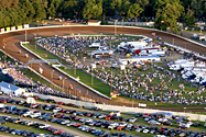
| Carlisle Events |
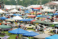 The Cars, the People, the Excitement. For more than 40 years, Carlisle Events has been a staple in the automotive community. Its passion is legendary to those who have made Carlisle, PA their “Automotive Hometown.” Carlisle Events hosts
9 seasonal automotive events at the Carlisle, PA Fairgrounds which attract enthusiasts from all over the world. The events are the Spring Carlisle, Import Performance Nationals, Ford Nationals, Chevrolet Nationals, Chrysler Nationals, the Hurst Nationals, Carlisle Truck Nationals, Corvettes at Carlisle, and Fall Carlisle.
See our Calendar of Events page for specific dates.
The Cars, the People, the Excitement. For more than 40 years, Carlisle Events has been a staple in the automotive community. Its passion is legendary to those who have made Carlisle, PA their “Automotive Hometown.” Carlisle Events hosts
9 seasonal automotive events at the Carlisle, PA Fairgrounds which attract enthusiasts from all over the world. The events are the Spring Carlisle, Import Performance Nationals, Ford Nationals, Chevrolet Nationals, Chrysler Nationals, the Hurst Nationals, Carlisle Truck Nationals, Corvettes at Carlisle, and Fall Carlisle.
See our Calendar of Events page for specific dates.
|
| Hershey |
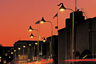 Hershey, The Sweetest Place on Earth. With thrilling attractions,
luxurious accommodations, mouth-watering treats, and plenty to do
the whole year round, it’s no wonder this chocolate-scented candy
kingdom is such a popular destination for the whole family. Come and
visit the town made famous by Milton S. Hershey’s company, where the
streets are lined with Hershey’s Kisses-shaped street lights and the
air is filled with the sweet smell of chocolate. Fun, sweetness and
adventure await at Hershey’s Chocolate World. You’ll be greeted by
giant Hershey’s Product Characters as you enter this delightful
world of food, shops and entertainment devoted to all things
chocolate. You’re invited to learn how chocolate is made at a
special presentation. Experience Hershey’s Kiss Works and the
sensational Hershey’s Really Big 3-D Show. Ready for all-out,
non-stop family fun? Hersheypark is the “cleanest and greenest theme
park in America” with more than 65 rides and attractions, including
11 exciting coasters, a five acre water play area that is
reminiscent of the beaches and boardwalks of the Northeast, and more
than two dozen kiddie rides. Plus live entertainment, photo ops
with Hershey’s Product Characters, challenging games of skill,
one-of-a-kind shops, and irresistible food.
Hershey, The Sweetest Place on Earth. With thrilling attractions,
luxurious accommodations, mouth-watering treats, and plenty to do
the whole year round, it’s no wonder this chocolate-scented candy
kingdom is such a popular destination for the whole family. Come and
visit the town made famous by Milton S. Hershey’s company, where the
streets are lined with Hershey’s Kisses-shaped street lights and the
air is filled with the sweet smell of chocolate. Fun, sweetness and
adventure await at Hershey’s Chocolate World. You’ll be greeted by
giant Hershey’s Product Characters as you enter this delightful
world of food, shops and entertainment devoted to all things
chocolate. You’re invited to learn how chocolate is made at a
special presentation. Experience Hershey’s Kiss Works and the
sensational Hershey’s Really Big 3-D Show. Ready for all-out,
non-stop family fun? Hersheypark is the “cleanest and greenest theme
park in America” with more than 65 rides and attractions, including
11 exciting coasters, a five acre water play area that is
reminiscent of the beaches and boardwalks of the Northeast, and more
than two dozen kiddie rides. Plus live entertainment, photo ops
with Hershey’s Product Characters, challenging games of skill,
one-of-a-kind shops, and irresistible food.
|
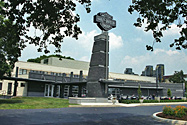
| Gettysburg National Military Park |
|
A New Birth of Freedom. The Battle of
Gettysburg was a turning point in the Civil War,
the Union victory in the summer of 1863 that
ended General Robert E. Lee’s second and most
ambitious invasion of the North. Often referred
to as the “High Water Mark of the Confederacy”,
it was the war’s bloodiest battle, with 51,000
casualties. It also provided President Abraham
Lincoln with the setting for his most famous
address. Begin your visit to the park at the new
Gettysburg Museum and Visitor Center. Funded
through donations coordinated by the Gettysburg
Foundation, the new facility had its grand
opening on September 26, 2008. The center
features a museum gallery on the Civil War and
Gettysburg, the film “A New Birth of Freedom”,
the newly conserved Gettysburg Cyclorama, a
bookstore and refreshment saloon. The park
offers a full compliment of Summer Ranger
Programs (mid-June through mid-August),
battlefield walks, ranger-led anniversary battle
walks, evening campfire programs, and special
events on weekends including living history
groups and band concerts.
|
| Harley Davidson Factory Tour |
 Passion Forged In Steel. Established as an assembly
facility in 1973, Harley-Davidson Vehicle
Operations in York, PA. is the largest
Harley-Davidson manufacturing facility. The York
facility covers more than 230 acres and has over
1.5 million square feet under roof. Employees
assemble the Touring and Softail® models, as
well as limited production, factory-custom
motorcycles. They perform a variety of
manufacturing operations—from machining,
polishing and chrome plating, to forming,
welding and painting. At the Vaughn L. Beals
Tour Center, you’ll explore exhibits that detail
the plant’s history, and guide you through the
manufacturing and assembly processes. You’ll
also have the chance to sit on current
production motorcycles and visit the gift shop
for tour-related souvenirs. The Kids’ Rally, a
specially designed area for visitors under the
age of 12, makes the York facility an ideal
family destination. Your journey begins with an
introductory movie and continues on the factory
floor where you’ll get a behind-the-scenes look
at the people, processes and products of York
Vehicle Operations. You’ll be guided through
various manufacturing and assembly areas, watch
as parts are manufactured and see freshly
painted and chrome plated parts. Then it’s on to
the end of the line, where every motorcycle is
roll-tested prior to crating and shipping. Over
the years, thousands of Harley-Davidson
enthusiasts have made the journey to York. Tours
are free and last approximately one hour.
Passion Forged In Steel. Established as an assembly
facility in 1973, Harley-Davidson Vehicle
Operations in York, PA. is the largest
Harley-Davidson manufacturing facility. The York
facility covers more than 230 acres and has over
1.5 million square feet under roof. Employees
assemble the Touring and Softail® models, as
well as limited production, factory-custom
motorcycles. They perform a variety of
manufacturing operations—from machining,
polishing and chrome plating, to forming,
welding and painting. At the Vaughn L. Beals
Tour Center, you’ll explore exhibits that detail
the plant’s history, and guide you through the
manufacturing and assembly processes. You’ll
also have the chance to sit on current
production motorcycles and visit the gift shop
for tour-related souvenirs. The Kids’ Rally, a
specially designed area for visitors under the
age of 12, makes the York facility an ideal
family destination. Your journey begins with an
introductory movie and continues on the factory
floor where you’ll get a behind-the-scenes look
at the people, processes and products of York
Vehicle Operations. You’ll be guided through
various manufacturing and assembly areas, watch
as parts are manufactured and see freshly
painted and chrome plated parts. Then it’s on to
the end of the line, where every motorcycle is
roll-tested prior to crating and shipping. Over
the years, thousands of Harley-Davidson
enthusiasts have made the journey to York. Tours
are free and last approximately one hour.
|
| Williams Grove Speedway |
 The Best In Sprint Car Racing. Located in
Mechanicsburg, Pennsylvania, the half-mile
Williams Grove Speedway has been part of the
rich history of motorsports throughout the
nation and the world since the gates were first
opened in 1939. Tommy Hinnershitz won the
first-ever event contested before weekly sprint
car racing began in 1967. Prior to that time
stock car racing was the norm before it evolved
into coupes and the famed 30x90 bugs. The
Cumberland County oval has been the playing
field for not only some of the most recognized
sanctioning bodies in auto racing but also for
the finest drivers to ever strap themselves into
an open-cockpit car. National champions like Ted
Horn, A.J. Foyt and Mario Andretti have raced at
the Grove, which has laid the framework for what
has come to be known as the best in the sprint
car business competing on a regular basis.
Today, Williams Grove hosts weekly programs of
the best sprint car racing, featuring a family
atmosphere and affordable prices.
The Best In Sprint Car Racing. Located in
Mechanicsburg, Pennsylvania, the half-mile
Williams Grove Speedway has been part of the
rich history of motorsports throughout the
nation and the world since the gates were first
opened in 1939. Tommy Hinnershitz won the
first-ever event contested before weekly sprint
car racing began in 1967. Prior to that time
stock car racing was the norm before it evolved
into coupes and the famed 30x90 bugs. The
Cumberland County oval has been the playing
field for not only some of the most recognized
sanctioning bodies in auto racing but also for
the finest drivers to ever strap themselves into
an open-cockpit car. National champions like Ted
Horn, A.J. Foyt and Mario Andretti have raced at
the Grove, which has laid the framework for what
has come to be known as the best in the sprint
car business competing on a regular basis.
Today, Williams Grove hosts weekly programs of
the best sprint car racing, featuring a family
atmosphere and affordable prices.
|
| Hollywood Casino at Penn National Race Course |
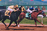 You’re On the Right Track. Hollywood Casino at Penn
National Race Course continues to build upon its
foundation of history and tradition that has
made it a major force in the sports and
entertainment market in Central Pennsylvania.
Turf racing is featured on a
nationally-acclaimed seven-furlong course. For
added excitement, the park simulcasts the
nation’s best racing seven days each week. In
2006 approval was received from the Pennsylvania
Gaming Control Board in Harrisburg, Pa., that
granted a permanent Category 1 slot machine
license to the track’s parent company. When
completed, the facility will be a 365,000 square
foot state-of-the-art integrated racing and
gaming operation, opening with 2,000 slot
machines.
You’re On the Right Track. Hollywood Casino at Penn
National Race Course continues to build upon its
foundation of history and tradition that has
made it a major force in the sports and
entertainment market in Central Pennsylvania.
Turf racing is featured on a
nationally-acclaimed seven-furlong course. For
added excitement, the park simulcasts the
nation’s best racing seven days each week. In
2006 approval was received from the Pennsylvania
Gaming Control Board in Harrisburg, Pa., that
granted a permanent Category 1 slot machine
license to the track’s parent company. When
completed, the facility will be a 365,000 square
foot state-of-the-art integrated racing and
gaming operation, opening with 2,000 slot
machines.
|
| Flat Rock Trail |
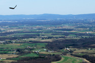 Hiking Flat Rock. Hiking Flat Rock.
Flat Rock Trail is 2.5 miles long (one way) leading from
Colonel Denning State Park to the
top of Blue Mountain in
Tuscarora State Forest. The trail
head is at the footbridge next to the environmental classroom. This
is a moderate to rugged hike climbing in elevation over 900 feet
with rocks and loose gravel. At the top of the mountain, Flat Rock
Trail joins the
Tuscarora Trail to the overlook.
Flat Rock Trail overlook is a natural rock outcrop that affords a
180-degree spectacular view of Cumberland Valley. Wear good hiking
boots and bring snacks and a drink.
Download Recreational Guides and Maps: |
| Army Heritage Center Foundation |
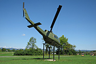 Telling the Army Story … One Soldier at a Time. The Army
Heritage Center Foundation continues to strive to expand the US Army
Heritage and Education Center (AHEC) campus and enhance its
programs. Currently, the Foundation is managing construction of
phase one of the Visitor and Education Center, a key component of
the Army Heritage and Education Center campus. The Visitor and
Education Center (VEC) will be the focal point for all campus
educational activities and will serve as the primary point of entry
into the AHEC Campus.
Telling the Army Story … One Soldier at a Time. The Army
Heritage Center Foundation continues to strive to expand the US Army
Heritage and Education Center (AHEC) campus and enhance its
programs. Currently, the Foundation is managing construction of
phase one of the Visitor and Education Center, a key component of
the Army Heritage and Education Center campus. The Visitor and
Education Center (VEC) will be the focal point for all campus
educational activities and will serve as the primary point of entry
into the AHEC Campus. |
| Cumberland Valley Rail Trail |
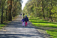 Rails to Trails Bike Trail … 11-miles, from Shippensburg to Newville. Trail enthusiasts can enjoy walking, jogging, bicycling, horseback riding and other non-motorized recreational uses. The trail, which is wheelchair-accessible, has a crushed limestone surface except for the last 1/2 mile at the Newville trail head which is paved. All of the road crossings between these two points have been graded to meet ADA specification and paved if it is a long grade. There are two missing bridges that limit access to 1 mile of trail at the Shippensburg end and 1/2 mile at the Newville end. Trail users will appreciate a variety of settings as the trail traverses wooded areas and farmland between the historic towns of Shippensburg and Newville. A shaded picnic area in the village of Oakville provides a pleasant rest stop along the way.
|
| Meadowbrooke Gourds |
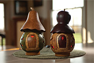 Unique Hand-Crafted Gifts. Meadowbrooke Gourds is an ornamental crafts farm and company based out of Carlisle, Pennsylvania. 4 miles from Dogwood Acres Campground. This company produces several lines of Ornamental Gourd decorations and accessories and is considered one of the best Ornamental Gourd suppliers in the country.
|
| Waggoner’s Gap Hawk Watch |
| A Prime Raptor Lookout. Waggoner’s Gap is small gap in the Kittatinny Ridge (also called Blue and North Mountain) where PA Route 74 crosses between Cumberland and Perry Counties. It was named for a family with extensive landholdings at the base of the mountain in Cumberland County, not for its use by wagons. Hawk watching and counting have been done from two sites over the years. The first, at the concrete tower along Route 74, was used as an alternate during inclement weather. The main site sits on the spine of the mountain 75 yards east of the highway. This site is essentially a rock pile with steep descents on both sides. This enables watchers to see both sides of the ridge from one spot. This gives the advantage of being able to see off wind birds easily and increases the wind directions that are productive without requiring a physical move. The ridge runs from the ENE to WSW. The nearest major ridge to the south is South Mountain, roughly 12 miles distant. The nearest major ridge to the north is Tuscarora Mountain, roughly 14 miles away. This expanse on both sides helps limit diffusion of the flight. Trees on both sides of the ridge limit visibility of low flying birds. They also prevent detection of low flying birds coming down the ridge until they are close to the lookout. It also prevents low flying raptors from seeing the hawk watchers until they are close. Best winds are NW and S, with higher numbers seen with NW winds, but closer views on the S winds. |
| Additional Local Businesses of Interest |
|
Finkenbinder’s North Mountain Butcher • Graziella’s Pizza & Subs Italian Restaurant •
Kimberly’s Cafe & Creamery • Rustic Tavern • • Beverage Express • Saylor’s Market • Bender Auto Parts • • Capital Auto Glass • High Peak Tent Rentals • Stan’s Beverage • Jaymee Lee’s Diner • Jaymee Lee’s Quickstop • Real Estate Excel • Hat Creek Wine Shop • Meadowbrook Gourds • Big Spring Pharmacy • D&G RV & Camper Repair • Strouse Entertainment • |
| More Information |
|
Pennsylvania Tourism Cumberland Valley Visitors Bureau Greater Carlisle Area Chamber of Commerce |